Is gravity the same across the Earth? And why is it important? / La gravità è la stessa su tutta la Terra? E perché è importante?
Is gravity the same across the Earth? And why is it important? / La gravità è la stessa su tutta la Terra? E perché è importante?
Segnalato dal Dott. Giuseppe Cotellessa / Reported by Dr. Giuseppe Cotellessa
The Earth is rough and has different masses at
different locations, and the gravitational field
accompanies these variations, which occur
according to the density of rocks under the ground
and other factors. After all, the distribution of mass
on the planet is heterogeneous.
The Earth's mass distribution controls the level at
which seawater will be at any given time, as the
instantaneous surface of the sea adjusts according
to the gravity field. In fact, there isn't even a sea
level, but an average or an instantaneous sea level.
There is a difference between the theoretically
calculated gravity and the actual value of the
acceleration of gravity of a particular place on the
planet. This difference is called the “gravitational
anomaly”, and it can be measured based on a
model that considers the dimensions, mass and
rotation of the planet.
This anomaly is observed on Earth, as it does not
have the same gravitational force everywhere. This
can be measured using a device called a
gravimeter, or, better yet, using satellites. The
notion that our planet has different gravitational
points depending on location has been around for
more than a century, but only recently have
scientists been able to create an accurate model
with the help of equipment positioned in Earth's
orbit.
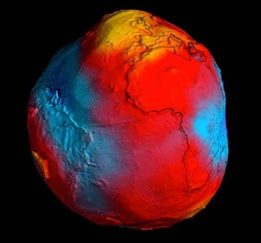
According to this map, a person's weight would be
1% lower in India. Below is the geoid created by
GOCE, this time showing that the Earth would
have a slightly potato-like shape.
Geoid heights range from +40 meters in the Andes
regions (Bolivia and Peru) to -20 meters in the
northern and northeastern regions of Brazil. But
the Andes, despite being 6,000 meters high, don't
have much more mass than the Amazon, according
to Blitzkow. “If we could weigh a cylinder from
the surface of a mountain in the Andes and another
from the Amazon, we would see that the difference
in weight is not as intense as the variation in
altitude”. In other words, it doesn't matter much
whether we are in a mountain or a valley - what
really interferes with the gravitational force is the
mass contained in the region's subsoil.
For us humans, these differences in gravity may be
insignificant, but they have a big impact on ocean
dynamics and heat circulation around the planet.
Therefore, high-precision geoids can help in
climate studies, understanding the Earth's internal
structure, understanding the dynamics of ice and
sea level change, among other phenomena that
affect life on Earth. Understanding the planet's
gravitational anomaly could even help scientists
learn more about the tectonic activity that causes
earthquakes and volcanoes.
ITALIANO
La terrra è ruvida e ha masse diverse in luoghi
diversi, ed il campo gravitazionale accompagna
queste variazioni, che si verificano a seconda della
densità delle rocce sotto terra e di altri fattori
. Dopotutto, la distribuzione della massa sul pianeta
è eterogenea.
La distribuzione della massa terrestre controlla il
livello al quale si troverà l'acqua di mare in un dato
momento, poiché la superficie istantanea del mare
si adatta in base al campo gravitazionale. Infatti
non c'è nemmeno un livello del mare, ma un livello
del mare medio o istantaneo.
C'è una differenza tra la gravità teoricamente
calcolata ed il valore effettivo dell'accelerazione di
gravità di un particolare luogo del pianeta. Questa
differenza è chiamata “anomalia gravitazionale”, e
può essere misurata sulla base di un modello che
considera le dimensioni, la massa e la rotazione del
pianeta.
Questa anomalia si osserva sulla Terra, poiché non
ha la stessa forza gravitazionale ovunque. Questo
può essere misurato utilizzando un dispositivo
chiamato gravimetro o, meglio ancora, utilizzando
i satelliti. L'idea che il nostro pianeta abbia diversi
punti gravitazionali a seconda della posizione
esiste da più di un secolo, ma solo di recente gli
scienziati sono stati in grado di creare un modello
accurato con l'aiuto di apparecchiature posizionate
nell'orbita terrestre.
Secondo questa mappa, il peso di una persona
sarebbe inferiore dell'1% in India. Di seguito è
riportato il geoide creato da GOCE, che questa
volta mostra che la Terra avrebbe una forma
leggermente simile a una patata.
Le altezze del geoide vanno da +40 metri nelle
regioni andine (Bolivia e Perù) a -20 metri nelle
regioni settentrionali e nord-orientali del Brasile
. Ma le Ande, nonostante siano alte 6.000 metri,
non hanno molta più massa dell'Amazzonia,
secondo Blitzkow. “Se potessimo pesare un
cilindro dalla superficie di una montagna delle
Ande ed un altro dell'Amazzonia, vedremmo che la
differenza di peso non è così intensa come la
variazione di altitudine”. In altre parole, non
importa molto se ci troviamo in una montagna o in
una valle: ciò che realmente interferisce con la
forza gravitazionale è la massa contenuta nel
sottosuolo della regione.
Per noi umani, queste differenze di gravità
possono essere insignificanti, ma hanno un grande
impatto sulla dinamica degli oceani e sulla
circolazione del calore intorno al pianeta. Pertanto,
geoidi ad alta precisione possono aiutare negli
studi sul clima, comprendere la struttura interna
della Terra, comprendere le dinamiche del
cambiamento del livello del mare e del ghiaccio
, tra gli altri fenomeni che influenzano la vita sulla
Terra. Comprendere l'anomalia gravitazionale del
pianeta potrebbe persino aiutare gli scienziati a
saperne di più sull'attività tettonica che causa
terremoti e vulcani.
Da:
https://www.freeastroscience.com/2021/08/is-
gravity-same-across-earth-and-why-is.html


Commenti
Posta un commento