Una serie "sbalorditiva" di 19.000 vulcani sottomarini scoperti con satelliti radar ad alta risoluzione / 'Mind boggling' array of 19,000 undersea volcanoes discovered with high-resolution radar satellites
Una serie "sbalorditiva" di 19.000 vulcani sottomarini scoperti con satelliti radar ad alta risoluzione / 'Mind boggling' array of 19,000 undersea volcanoes discovered with high-resolution radar satellites
Segnalato dal Dott. Giuseppe Cotellessa / Reported by Dr. Giuseppe Cotellessa
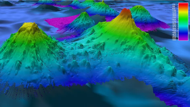
La montagna sottomarina Pao Pao nell'Oceano Pacifico meridionale è stata mappata dal sonar, mentre migliaia di altre montagne sottomarine sono state appena scoperte dai satelliti / Pao Pao Seamount in the South Pacific Ocean has been mapped by sonar, while thousands of other seamounts are just now being discovered by satellites.
Gli scienziati hanno utilizzato satelliti radar ad alta risoluzione e hanno scoperto 19.000 vulcani da capogiro.
I satelliti radar ad alta definizione hanno rivelato più di 19.000 vulcani sottomarini intorno al nostro pianeta, fornendo agli scienziati il catalogo più completo di montagne sottomarine mai creato. Il nuovo compendio, che è stato pubblicato il 6 aprile sulla rivista Earth and Space Science, potrebbe fornire una migliore comprensione delle correnti oceaniche, della tettonica a placche e dei cambiamenti climatici.
Prima di questo, solo un quarto del fondo marino terrestre era stato mappato utilizzando il sonar, che utilizza le onde sonore per rilevare oggetti nascosti sott'acqua. Un censimento del sonar del 2011 ha rilevato più di 24.000 montagne sottomarine, o montagne sottomarine formate dall'attività vulcanica. Tuttavia, ci sono più di 27.000 montagne sottomarine che rimangono inesplorate dal sonar, secondo l'articolo di Science.
"È semplicemente sbalorditivo", David Sandwell, un geofisico marino della Scripps Institution of Oceanography che ha lavorato al sondaggio, ha detto alla rivista Science.
Tuttavia, il nuovFinora, i ricercatori hanno mappato una raccolta di montagne sottomarine nell'Oceano Atlantico nord-orientale che potrebbe aiutare a spiegare l'evoluzione di un pennacchio di mantello che alimenta più di 100 vulcani in Islanda. Queste mappe aggiornate forniranno anche una migliore comprensione delle correnti oceaniche e delle "risalite", che si verificano quando l'acqua dal fondo dell'oceano ribolle verso l'alto verso la superficie - un fenomeno che gli scienziati pensano possa essere "concentrato su montagne sottomarine e creste", secondo l'articolo di Scienza.
"C'è uno zoo di cose interessanti che accadono quando hai la topografia", Brian Arbic, un oceanografo fisico dell'Università del Michigan ad Ann Arbor che non era coinvolto nello studio, ha detto a Science.
ENGLISH
Scientists used high-resolution radar satellites and discovered a 'mind boggling' 19,000 volcanoes.
High-definition radar satellites have revealed more than 19,000 undersea volcanoes around our planet, providing scientists with the most comprehensive catalog of seamounts ever created. The new compendium, which was published April 6 in the journal Earth and Space Science, could provide a better understanding of ocean currents, plate tectonics and climate change.
Prior to this, only one-quarter of Earth's seafloor had been mapped using sonar, which uses sound waves to detect objects hidden underwater. A 2011 sonar census found more than 24,000 seamounts, or undersea mountains formed by volcanic activity. However, there are more than 27,000 seamounts that remain uncharted by sonar, according to the Science article.
“It’s just mind boggling,” David Sandwell, a marine geophysicist at the Scripps Institution of Oceanography who worked on the survey, told Science magazine.
However, the new study shows that scientists don’t need to rely on sonar surveys to investigate what’s going on under the ocean. Radar satellites not only measure an ocean's height but can also see what's lurking in the water's inky depths, offering a better representation of the topography of the seafloor. Scientists pulled data from several satellites, including the European Space Agency's CryoSat-2, and found that they could detect underwater mounds as small as 3,609 feet (1,100 meters) tall, which is the lower limit of what constitutes a seamount, according to the Science article.
With this technology, scientists predict they can estimate the heights of small undersea volcanoes to an accuracy of approximately 1,214 feet (370 m), according to the study.
So far, researchers have mapped a collection of seamounts in the northeast Atlantic Ocean that could help explain the evolution of a mantle plume that feeds more than 100 volcanoes in Iceland. These updated maps will also provide a better understanding of ocean currents and "upwellings," which occur when water from the bottom of the ocean churns upward to the surface — a phenomenon that scientists think could be "concentrated at seamounts and ridges," according to the Science article.
"There's a zoo of interesting things that happen when you have topography," Brian Arbic, a physical oceanographer at the University of Michigan in Ann Arbor who wasn't involved with the study, told Science.
Da:
https://www.livescience.com/planet-earth/rivers-oceans/mind-boggling-array-of-19000-undersea-volcanoes-discovered-with-high-resolution-radar-satellites?utm_term=0D44E3E5-72C8-4F2E-A2B4-93C82DC78FB4&utm_campaign=368B3745-DDE0-4A69-A2E8-62503D85375D&utm_medium=email&utm_content=C3071B9F-BAEA-419C-A2AC-4014CF28A26C&utm_source=SmartBrief


Commenti
Posta un commento